

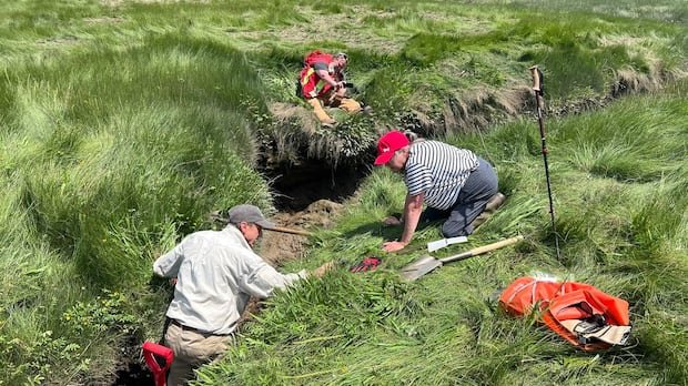

On a waterway in the southwestern part of Nova Scotia, a historical investigator is delving into the ancient remnants of North America’s bygone era.
Allains River, previously known as Lequille River, meanders as a tributary of the Annapolis River, traversing from the province’s interior to present-day Annapolis Royal.
Approximately four centuries ago, the river harbored one of the earliest industrial enterprises post-colonization: a flour mill erected in 1607 and later ravaged by flames in 1643.
For generations, the precise whereabouts of this mill remained elusive. However, an amateur historian from the United States, alongside a group of scholars and archaeologists, is now making headway in pinpointing its location. This endeavor is shedding light on the narrative of colonization, interactions, and the enduring presence of the Mi’kmaw people in Nova Scotia.
Mark Borton, a writer hailing from Connecticut who spearheaded the quest for the Poutrincourt gristmill, described it as a captivating conundrum and a profoundly significant site due to the myriad events that transpired there.
In 1605, a fortified fur-trading outpost was constructed at what Samuel de Champlain dubbed as Port Royal on the Annapolis Basin. The settlers required a mill to produce flour, as bread comprised a substantial portion of the French diet at the time.
The Poutrincourt gristmill, a water-driven facility for grinding grains, is depicted on maps from that era, notably on Champlain’s cartography.
This map caught Borton’s attention, a former creator of boating guidebooks, during a visit to the Maritimes in 2018. His fascination with tidal power and the Bay of Fundy led him to the realization of the mill’s historical significance.
By analyzing Champlain’s map in conjunction with contemporary geographic features, Borton managed to narrow down a potential site. Through satellite imagery, he spotted a faint square on the marsh’s edge, possibly indicating a foundation.
Securing a permit from the Nova Scotia Museum, Borton continued his investigation to validate his theory.
One significant clue was the presence of a Mi’kmaw fishing weir opposite the mill on Champlain’s map, which Borton corroborated by identifying a rock pile at that location on Google Maps.
In the summer, Borton, in collaboration with the Nova Scotia Museum, gathered samples from the dikes’ wooden structures for radiocarbon dating, enhancing the credibility of his hypothesis.
Borton enlisted the support of archaeologists from Kwilmu’kw Maw-klusuaqn, a group dedicated to safeguarding archaeological assets recognized by the Assembly of Nova Scotia Mi’kmaw Chiefs, and Saint Mary’s University.
Jonathan Fowler, an anthropology professor at Saint Mary’s, underscored the project’s alignment with his team’s research on the period of French-Mi’kmaq interaction. Allains River represents a pivotal chapter in this historical narrative, embodying a convergence of European and Indigenous land uses.
Fowler’s team intends to employ ground-penetrating radar for further exploration at the mill site, viewing this collaborative endeavor as a tale of a shared landscape resonating with lessons for the present and future.
Borton’s investigations have also brought to light several other mill sites in the vicinity, potentially constituting a cluster of national historic sites within a compact area along Allains River. He hopes that unveiling the truth will advocate for preservation, considering the multicultural tapestry of Mi’kmaq, French-Acadian, and British influences found in the region.